十勝岳
Mt. Biei and Tokachi
Elevation: 2077m
Prefecture
Hokkaido
Distance
16 km
Elevation Gain
1550m
Time
8-9 Hours
Difficulty
4/5
Accommodation
Hotels or Campsites
Overview
Mt. Tokachi is a large and active volcano in Daisetsuzan National Park, it's part of the Hyakumeizan and is often hiked as a loop trail that includes Mt. Biei. Mt. Biei is a neighbouring peak and a highly recommended inclusion for the Mt. Tokachi hike because this is where the most enjoyable terrain and the most stunning views are found. However, if you are short on time, you can do either mountain as an out-and-back day hike which will take about 6 hours.
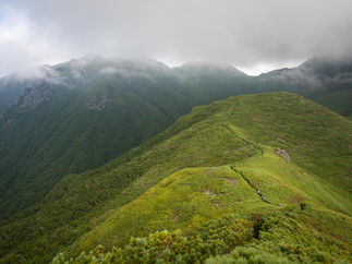
The terrain for Mt. Biei includes a lot of variety such as mellow forest sections, a river crossing, a ravine with ropes & ladders plus small icebergs, and a steep trail with rocks and tree roots. Mt. Tokachi is an impressive alien landscape of volcanic terrain, although the trail itself can be quite monotonous. The ridgeline between the two mountains is an enjoyable transition with gorgeous views.
Another popular attraction is the free and natural open-air onsen, located close to the trailhead here.
It's worth noting that wind on these mountains can be very strong even on sunny days, and there are some sections where the volcanic gas can mildly affect your breathing. Mt. Tokachi is an active volcano, it may be closed if there is an increase in volcanic activity. It had major eruptions in 1926 and 1962, with a recent but somewhat mild eruption in 2004.
Access
Car: If using a car then you'll be parking at the free Bogakudai parking lot. During the summer peak season on weekends and holidays it's often full by 7:30am, with overflow parking going up the side of the road.
Train + Bus: You'll need to reach Fukiage Onsen, or Tokachidake Onsen. The bus for both of these stops departs from Kamifurano Station. I could not find info for these busses on Google Maps, so you will need to confirm with the town's website for the most up-to-date information, or check out Lostfilipina.com for a good overview regarding the bus times. And lastly, the tourist info centre at Kamifurano will happily help you in English.
The Fukiage Onsen trailhead has a campground, which would be the best option if you don't have a car and want a full day hiking both peaks.
Maps
GPS map: Biei -Tokachi Loop Tokachi Onsen Trail

The hikes
Trail Descriptions
Bogakudai Trailhead: Mt. Biei to Tokachidake Loop Hike
GPS Hiking Map: outdooractive.com
Time: 9 hrs
Distance: 16 km
Elevation change: ➚ ➘ 1550m
Requiring a car or taxi, this is the famous loop hike featuring dramatic views and a variety of terrain. Starting from Mt. Biei is recommended because ending with Tokachi will provide an easier descent. The trail is well maintained and easy to follow, but be mindful of the weather forecast and bring adequate supplies as it's quite a big day.
Tokachidake Onsen Trailhead: The Out-&-Back Trail
GPS Hiking Map: outdooractive.com
Time: 7 hrs
Distance: 12.7 km
Elevation change: ➚ ➘ 1060m
The best trail for the out-&-back hike is from Tokachidake Onsen. If you want to do the full loop then it would be best to start from the Fukiage Onsen trailhead listed below and spend the night at the Hakuginso campground.
Fukiage Onsen Trailhead: Mt. Biei to Tokachidake Loop Hike
GPS Hiking Map: outdooractive.com
Time: 10 hrs
Distance: 17.5 km
Elevation change: ➚ ➘ 1450m
If you want to do the full loop of Mt. Biei and Tokachidake then it would be best to start from the Fukiage Onsen trailhead and spend a night at the nice Hakuginso campground. This will be a big day of hiking but well worth it, make sure you bring enough supplies for both hiking and camping as the facilities don't have much for you to buy. You could also spend a night at the campground and simply do the out-and-back hike.
Elevation Profile
Mt. Biei to Tokachidake Loop Hike

Tokachidake Onsen Out-&-Back Trail

Weather and Seasons
The summer months, from July to September, are considered the best times for this hike, outside of these months you will need to be prepared for snow. The first snowfall of the season typically lands around October. There will be an avalanche risk during the snow season from October to June.
Useful links
Cautions
Altitude & Weather
Bears (rare)
Volcanic Gas
Gallery

Difficulty: 4/5
Elevation Gain: 1550m
Time: 9 hrs
Hiking Distance: 16km
Prefecture: Hokkaido
Related Articles


