韓国岳
Mt. Karakuni
Elevation: 1700m
Prefecture
Kagoshima
Distance
8-10 km
Elevation Gain
750m
Time
5-6 Hours
Difficulty
3/5
Accommodation
Hotels & Campsites
Overview
Mt. Karakuni is the highest peak in the Kirishima-Kinkowan National Park, located near Kagoshima city. The Kirishima Mountains feature an incredible collection of active volcanic peaks, stunning crater lakes, and beautiful natural forests. The national park also features a lot of natural hot springs, with many accommodation options ranging from campgrounds to luxurious onsen hotels. One of the volcanic peaks, Shinmoedake, experiences regular eruptions and is often closed from hiking due to the volcanic activity.
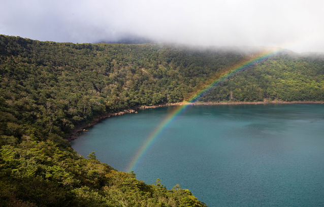
There are two main trails for hiking Mt. Karakuni, the most visually striking option includes the stunning Onami Crater Lake. The other trail loops passed the Onami lake so it's an optional extra depending on your time and mood. The views from Mt. Karakkuni are quite incredible, on clear days you can see the entire Kirishima volcanic range and all the way to Sakurajima.
The Kirishima mountains are the perfect example of how incredible the hiking in Kyushu can be, along with Mt. Aso and Mt. Kuju, the landscape and terrain found here is unbelievably beautiful - with the vibrant greenery of summer it feels like a fantasy world you might find in a video game. Kyushu truly is a hidden gem for travellers looking to explore the mountains of Japan.
Access
Car
The best way to access Kirishima and Mt. Karakuni is with a car, you can park at either, although the Onami Lake trailhead might be full on weekends & public holidays.
Onami Lake Trailhead: Google Maps
Ebino Kogen Trailhead: Google Maps
Public Transport
Some planning is needed if you're using public transport. First you will catch a bus to the Kirishima Onsen area, there are direct busses from Kagoshima Airpot (¥700) and you can find the times on Google Maps.
At Kirishima Onsen you catch another bus from the Maruo bus stop, there are 3 buses per day, starting from 8:30am, double check the current schedule here. It only takes about 20 minutes to reach the trailheads by bus.
From Osaka/Kyoto and Tokyo:
Flights to Kagoshima can vary a lot depending on the day, ranging from $100 to $200 USD one-way, check Skyscanner for the best options.
The overnight ferry from Osaka to Beppu is possibly the best way to travel to Kyushu - however, for Kagoshima, the ferry arrives at a distant port which requires an additional shuttle bus which takes 1hr 50mins to get into Kagoshima. Prices start from around ¥8000 and increase if you want a nicer room. The ferry is very nice and is an experience in itself. There is also a ferry from Tokyo to Fukuoka. Click here for Osaka, or here for Tokyo.
The overnight bus is the cheapest option, running from Kyoto and Osaka to Fukuoka, Kumamoto, and Beppu, it takes 10 to 12 hours and the price varies from ¥4000 to ¥10,000, with Fukuoka being the cheapest option. Click here for the bus to Fukuoka, here for the bus to Kumamoto, or here for the bus to Beppu.
Maps


Useful links
Weather and Seasons
The summer months including June, July, August, and September are the best time for hiking in Kirishima, the summer will give you a lush green landscape ideal for photos. It can get pretty warm with temperatures averaging around 32°C. Keep an eye on the forecast for possible typhoons, which peak in August and September. There is quite a bit of rain during summer, with June and July receiving the most rainfall.
Autumn provides the most comfortable temperature for hiking, and less rainfall, with the autumn colours reaching their peak around the end of October. Winter hiking is also possible, with snowfall occurring from December to March.

The hikes
Trail Description
Onami Lake Trailhead
GPS Hiking Map: outdooractive.com
Time: 5-6 hrs
Distance: 8.5 km
Elevation change: ➚ ➘ 750m
Trailhead ➝ Karakuni Peak: 2hr 30mins
If you're starting from the Onami Lake trailhead it will take about 40 mins to reach the first viewpoint at the lake, from here it's another hour and 40 mins to reach the peak of Karakuni. You can either head left or right to hike around the lake, the easiest path is to the left, which might be a good idea if you're trying to catch the sunrise.
Ebino Kogen Trailhead
GPS Hiking Map: outdooractive.com
Time: 5-6 hrs
Distance: 10.5 km
Elevation change: ➚ ➘ 650m
Trailhead ➝ Karakuni Peak: 1hr 40mins
The Ebino Kogen trailhead provides the fastest ascent to the peak of Karakuni, so it's a popular option if you want to catch the sunrise. From the peak, it will take about 50 mins to reach the intersection for Onami Lake. Even if you want to skip hiking around the lake, it's highly recommended to at least check out the nearest viewpoint. For the viewpoint, head left (south) and after about 10 minutes of hiking you'll reach some paths detouring off the trail for a view of the beautiful crater. Note that the thorn bushes on this section can become a little overgrown in summer. The full loop around the crater will take about 1.5hrs, and from the Onami Lake intersection it will take another hour to get back to Ebino Kogen.
Elevation Profile
Onami Lake Trailhead

Ebino Kogen Trailhead

Cautions
Altitude & Weather
Volcanic Activity
Gallery

Difficulty: 3/5
Hiking Distance: 8-10km
Time: 5-6 hrs
Elev. Change: 750m
Prefecture: Kagoshima
Related Articles


